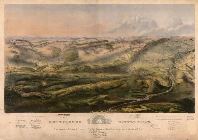
A map depicting the three-day battle of Gettysburg. Source: Library of Congress
Later this week, on August 25th, will be the U.S. National Park Service centennial (more about that on the day in question). So for all history buffs out there, you might enjoy the following article by National Geographic that provides a historical context to several topographical maps of the national parks (a somewhat contrasting view to yesterday’s post on fictional map creation) and their uncharted contribution to historians many years later.
By Betsy Mason
CAMBRIDGE, Mass.—John Badger Bachelder arrived at Gettysburg before the soldiers’ bodies were buried. He spent the next 84 days studying the battlefield by horseback and filling notebooks with the accounts of injured soldiers from both sides of the battle. He even took some of the wounded back to the scene so they could point out their positions and recount what had happened.
The striking panoramic map of Gettysburg (above) that Bachelder based on this work is meticulously detailed. It depicts where every Union and Confederate regiment stood during each of the three days of battle in July, 1863. His work was so accurate, in fact, that Bachelder was put in charge of deciding where most of the 1,320 physical monuments and markers would be placed in what is now Gettysburg National Military Park.
“I think it’s beautiful, and it just tells such a great story,” says Bonnie Burns, head of geospatial resources for the Harvard Map Collection.
Burns is a co-curator of a new map exhibit at Harvard celebrating the 100th anniversary of the formation of the National Parks Service. Burns and Harvard digital cartographer Scott Walker selected the maps entirely from within Harvard’s incredible collection of around 400,000 maps and atlases. Burns gave me a tour of the exhibit shortly after it opened in May.
Yellowstone

A 1871 map showing a portion of the Upper Geyser Basin. Source: U.S. Department of the Interior
Before Yellowstone became America’s first national park in 1872, Congress sent a group of surveyors led by geologist Ferdinand Vandeveer Hayden to explore and document the prospective park. The Hayden survey made the first detailed maps of some of the primary geothermal features. Incredibly, the fieldwork for the two maps of the Upper (above) and Lower Geyser Basins that are included in the exhibit were completed in just a week. “It was amazingly fast,” Walker says.
Hayden’s 500-page report on the area, including paintings by Thomas Moran and photographs by William Henry Jackson, helped convince Congress to create Yellowstone National Park. The National Parks Service wouldn’t come into existence for another 44 years.
Hawaii

1885 map of the island of Hawaii that shows the portion that later became a national park in 1916. Source: Library of Congress
Hawaii National Park became the 11th park in 1916, just weeks before the Park Service was formed. In 1961, the park was split into Hawai’i Volcanoes National Park on the Big Island and Haleakalā National Park on Maui. The map above of the Island of Hawaii was made in 1885 as part of the Hawaiian Government Survey, to determine what land the government had left to sell.
“I really like the history behind those Hawaii maps,” Burns says. The map shows the locations of former traditional land-use rights, based on areas known as ahupua’a. “They’re still drawn on the edges of the map so you can see which tribes, which clans had access to various parts, and how the land rights went from the ocean to the mountain, so that you get a whole slice—you get access to a lot of different aspects of the ecosystem.”
See the additional maps and their history here.
