It has been a while since we have seen any old maps of Iceland, or old images of anything for that matter, so combined with a few select Raxa bloggers receiving a near-final copy of Seth’s honors thesis for review a few moments ago, this announcement came as a pleasant surprise:
Last week, the New York Public Library released twenty thousand maps from its extensive collection, which includes more than four hundred thousand sheets and twenty thousand books and atlases, as free, high-resolution digital downloads. In announcing the newly accessible maps, the N.Y.P.L explained that the holding includes more than a thousand maps of New York City from the seventeenth century to the twentieth century, “which detail transportation, vice, real estate development, urban renewal, industrial development and pollution, political geography among many, many other things.”
Maps like these can be used to help historians visualize phenomena that have shaped the city. For example, they show how ethnic enclaves shifted as Italian, Jewish, and Chinese immigrants traded places in lower Manhattan or how Manhattan’s shoreline has grown outward, as a result of infill and real-estate speculation, creating new parts of the city where before there was only water.
Matt Knutzen, the curator of the N.Y.P.L’s map collection, is charged with helping the library determine how this vast repository of information can best be housed, catalogued, and viewed, both in the library and on the Web. He pointed out five particularly interesting maps of New York City and explained what they show us. (His text, below, has been condensed and edited.)
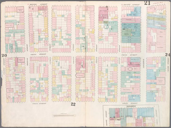
Plate 21 from “Maps of New York City,,” by William Perris (1857)
After large parts of New York City burned in 1835 and 1845, a military surveyor named William Perris began an ambitious project to map the city, building by building, so that fire-insurance companies could appropriately price their customers’ policies.
This map of what is now SoHo locates much of what was then Manhattan’s theatre district. Niblo’s Garden (which sat on the corner of Prince and Crosby Streets) is where the seminal American musical “The Black Crook” was performed in 1866. Nearby was Buckley’s, a blackface minstrel-theatre troupe, which closed its doors after the Concert Saloon Bill of 1862 outlawed the apparently explosive combination of booze, theatre stages, and female waitresses…
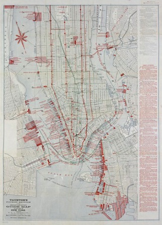
Pocket edition of “The Merchant’s and Shipper’s Guide Map to the Port of New York,” by S. D. L. Taunton (1879).
Read the whole post at the source.

Pingback: Umberto Eco, Come To Kerala! | Raxa Collective