Thanks to Jim Robbins and Yale e360:
CRISIS ON THE COLORADO: PART I
The West’s Great River Hits Its Limits: Will the Colorado Run Dry?
The headwaters of the Colorado River are in a marshy meadow in Rocky Mountain National Park.
As the Southwest faces rapid growth and unrelenting drought, the Colorado River is in crisis, with too many demands on its diminishing flow. Now those who depend on the river must confront the hard reality that their supply of Colorado water may be cut off. First in a series.
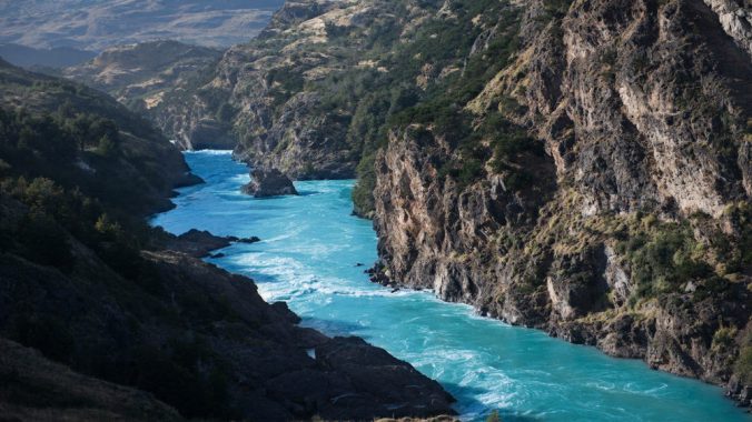
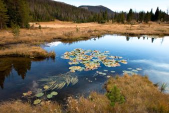
The beginnings of the mighty Colorado River on the west slope of Rocky Mountain National Park are humble. A large marsh creates a small trickle of a stream at La Poudre Pass, and thus begins the long, labyrinthine 1,450-mile journey of one of America’s great waterways.
Several miles later, in Rocky Mountain National Park’s Kawuneeche Valley, the Colorado River Trail allows hikers to walk along its course and, during low water, even jump across it. This valley is where the nascent river falls prey to its first diversion — 30 percent of its water is taken before it reaches the stream to irrigate distant fields.
The Colorado flows 1,450 from its source in Colorado to the southwest, ending just short of the Gulf of California. MAP BY DAVID LINDROTH
The Never Summer Mountains tower over the the valley to the west. Cut across the face of these glacier-etched peaks is the Grand Ditch, an incision visible just above the timber line. The ditch collects water as the snow melts and, because it is higher in elevation than La Poudre Pass, funnels it 14 miles back across the Continental Divide, where it empties it into the headwaters of the Cache La Poudre River, which flows on to alfalfa and row crop farmers in eastern Colorado. Hand dug in the late 19th century with shovels and picks by Japanese crews, it was the first trans-basin diversion of the Colorado. Continue reading


 When I see the name Peter Matthiessen the first thing I think of is a recording of his voice on my telephone ten years ago. I knew he would be passing nearby and had invited him to see